
Prof makes navigating storms easier for pilots
Imagine trying to memorize hundreds and hundreds of codes to understand and navigate through weather patterns.
This daunting task is exactly what flight technology and engineering students try to do.
Professor of plants, solids and biometeorology Robert Gillies has helped this process become just a little easier for students at Utah State University.
Gillies brought visual tactics into his classroom to try easing the learning process for his students. For doing so, he recently earned the Golden Mouse Award. The Golden Mouse Award is given twice a year to recognize those who have innovatively integrated technology into teaching and learning.
Up until just a few years ago students would simply try to memorize all the coded meteorological reports and forecasts. It is confusing and complicated, Gillies said, and difficult to memorize the codes with nothing to visualize.
“We are intuitively visual as humans. We key into visual elements,” Gillies said.
Gillies began teaching weather with visual aids using two programs, Unidata and McIDAS. These programs allow users, primarily educators and researchers, to access data and visualization software to explore earth-system phenomena.
The Unidata community has participants from atmospheric science, hydrology, oceanography, climatology, engineering and environmental science among other disciplines, though its primary focus is meteorology.
Users can look up weather information from any airport in the world. They can see fronts as they move across the globe, or pinpoint lightning. They can check the temperature, wind conditions and cloud status. All this information is provided in real time. The weather conditions they see are as they really are.
The information is provided in maps or graphs. It is an entirely visual presentation of the weather patterns.
This allows users to visualize the weather first and see the big picture, Gillies said.
“Then when you see the code you know what to expect, whether it be fog, a front, or lightning,” he said.
It helps students learn the codes because they are expecting to see certain things.
Gillies’ students found Unidata to be so helpful that they requested it be made available at the Logan Airport.
To receive data from Unidata, users must be affiliated with a degree-granting institution, or a not-for-profit institution with an education and/or research mission. Students in the flight technology and engineering program at USU use Unidata and the Logan Airport, so they fit the criteria to bring Unidata out to the airport. The problem was that the Logan Airport wasn’t set up to receive the information.
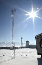
USU arranged for a radio frequency modem to send the necessary information from the Spectrum out to the airport. At that point airport officials needed to be convinced that the information Unidata and McIDAS could provide was worth building a tower to receive the information.
Students from USU found the information to be so helpful that they essentially built the tower to receive the information, Gillies said. In an effort to make it more affordable for the airport, USU students dug the hole, poured the concrete and hoisted up the tower.
It’s nice to be able to look up the information at the airport before you go up and fly, said Andrew Watts, a junior flight technology and engineering major.
Unidata is always on, said Deneal Yipe, a senior flight technology and engineering major, and “someone is always looking at it.”
-apassey@cc.usu.edu
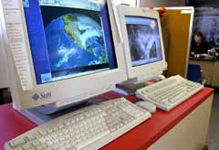
Computers at Logan Airport allow access to weather information. (Photo by Scott Davis)