
Six Years: Recent rain, snow could help with Utah’s drought
The last few weeks have seen unsusually large and welcome amounts of rain and snow that are helping to alleviate the six-year long drought Utah is experiencing.
Esmaiel Malek, associate professor of biometeorology at Utah State University and acting director of the Utah Climate Center, said the precipitation Utah has received this month is far above the calculated average, totalled from 1971 to 2000.
Malek said water is measured in terms of a ‘water year,’ which typically runs from Oct. 1 to Sept. 30 of the following year. All calculations are based on standards gathered from previous water years.
Malek said there are three stations in Logan where water levels are collected that help determine where Logan sits, precipitation-wise, in comparison to other years.
These stations are positioned at the Logan KNVU radio station, on the USU campus and on 500 South. According to a data sheet Malek provided, all three stations report precipitation levels as high as 233 percent above normal.
For instance, the normal average amount of precipitation collected at this time of year at the KNVU station is 1.78 inches, and to date this year, has collected 4.16 inches, he said.
“We hope that this trend [in precipitation] is going to continue to help eliminate the five-year drought that Utah has been experiencing,” Malek said. “But, even with all the precipitation we’ve had in the last couple of weeks, the drought is not going to be gone. It will take at least two to three years with this kind of precipitation, all year-round, to take care of the drought.”
According to the Climate Prediction Center Web site, www.cpc.ncep.noaa.gov, droughts may be classified using a system where specific areas are assigned an index number ranging from D0 to D4, based upon the areas risk for drought. A D0 area is classified as abnormally dry, and is assigned to areas showing dryness but is not yet in drought, or for areas recovering from drought, whereas a D4 is rated as exceptional and severe drought.
Utah is typically rated on this system as a D2, or severe drought risk area, Malek said. Even though the recent precipitation will not instantly fix the drought situation, he said, it does help.
Randy Julander, a hydrologist with the Utah Snow Survey, said Utah soil moisture values compared to last year are double, or triple in most areas. He said besides the precipitation received from rain, the mountains in many areas are also blanketed in snow, which helps saturate the soil, setting the stage for winter.
Malek said once the soil becomes saturated, or when it can not hold any more water, any excess turns into run-off which enters local lakes and rivers, helping raise water levels in them as well. In the last two years, the soil has been so dry in the fall that the spring snowmelt soaked right into the soil, rather than running off into the streams and reservoirs, he said.
“Any and all forms of precipitation really help make an impact,” Malek said. “And every little bit counts.”
Regarding the early snow in the mountains, Malek said soil moisture levels are not the only benefit.
“It’s very good to have [Brighton ski resort] open early. It’s good for the economy of the state, because it attracts so many people from all over,” Malek said.
Malek said he suggests anyone interested in monitoring Utah’s drought situation to visit the CPC Web site, www.cpc.ncep.noaa.gov, which contains the U.S. Drought Assessment Monitor.
According to the Web site, every Thursday, the CPC, along with the United States Department of Agriculture, the National Drought Mitigation Center in Lincoln, Neb., and NOAA’s National Climatic Data Center, issues a weekly drought assessment.
-amberem@cc.usu.edu
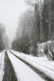
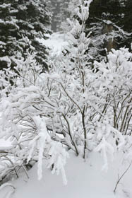
Thanks to recent storms, the road to Tony Grove Lake is looking like a winter wonderland. Twenty inches of snow were reported at Tony Grove this past week. (Photo by Becky Blankenship)