
Warm temps, rain could cause worse flooding this year
A flood warning was issued late Saturday morning for Northern Utah by the National Weather Service, warning residents of potential overflow of the Blacksmith Fork and the Lower Bear Rivers in southern Cache Valley, the Weber River and Emigration Creek. With rain and temperatures in the 60s Sunday, the warning will remain in effect until Monday afternoon.
Another warning issued Saturday for Northern Utah and Southwest Wyoming alerted residents that warm temperatures would cause increased snowmelt and potential flooding. A storm system is expected to impact the area Sunday and Monday and will increase the amount of water in the rivers even more.
All signs point to flooding in Cache Valley. In addition to the high snowpack this year, the mid-April snowstorm and several days of rain will have added more water to the already-saturated valley.
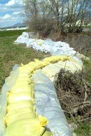
The fact that Logan is surrounded by mountains, usually a point of pride for its residents, becomes more of an annoyance each spring when a winter’s worth of snowpack begins to melt and run into the valley. Past years have caused major flooding of the valley’s river systems, so this year’s high snowpack has more than a few people worried. Several events have been organized in Logan to prepare sandbags to be ready for an emergency.
According to some reports, flooding is expected to be worse this year than last year in Cache Valley. Water tables are high and several rivers are anticipated to overflow their banks. According to a report by KSL-TV April 19, it looks like Logan will be one of the places in Utah hit hardest by floodwaters on Monday.
For the main Utah State University campus, there isn’t much to worry about, according to Assistant Vice President for Facilities Darrell Hart. Being located on a hill has more benefits than a good view.
“On-campus [preparation] is easy since we are high ground,” he said in an e-mail.
There are several facilities owned by USU not at its main campus. These are located around Cache Valley and all over Utah.
The Utah Water Research Laboratory is located in Logan Canyon. The Logan River runs not far from the facility. Hart said the UWRL is “in good shape for the most part” because the banks of the Logan are high around that part of the river.
The Agricultural Experiment Station is a collection of 24 research farms and labs scattered across Utah, with seven of its 11 research farms in Cache Valley. Paul Rasmussen, director of the Experiment Station, said the places most likely to experience flooding are the South Farm and the Caine Dairy in Wellsville. He said Wellsville already has a high water table, but that’s normal for that area.
“We’ve never had a problem in my time,” he said.
Both the South Farm and the Caine Dairy are home to livestock, though Rasmussen did not know how many exactly, since the number is always in flux. However, he said provisions have already been made to move the animals in case of a flood.
“Trailers are set up. We could move a large amount of animals in a short amount of time,” he said.
Hart said the east side of Highway 89/90 tends to hold a lot of water. However, he said their problems generally remain during the heavy irrigation season and don’t necessarily increase with spring floods.
Hart said the canals should be opened about mid-May to help assuage to the water runoff and most problems occur for those with low-lying land in a river’s flood plain. That’s where most flooding and sandbagging occur, he said.
-ella@cc.usue.edu